[00:05.4]
everybody, my name is Adam DeLuca, I'm the director of Risk Intelligence here at Everbridge and I'm joined here today by Caitlin Gillespie, our new Chief of Meteorology here at Everbridge. And you know, we just want to jump on real quick. There's obviously a major developing situation in the western Pacific.
[00:22.2]
So far the strongest storm of the year to date. And we wanted Caitlin to kind of get on and share her expertise. So Caitlin, could you maybe explain to us what, what's going in the western Pacific, why the storm so serious and why we should pay attention to it? Absolutely.
[00:37.7]
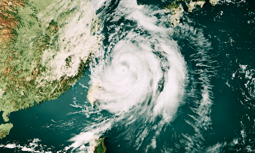
Thank you so much for having me on, Adam. So Sin Lake, who really put on a display of rapid intensification yesterday in the western Pacific and it reached that peak intensity of category 5 hurricane equivalent intensity with maximum sustained winds of 185 mph.
[00:56.2]
Now that is all due to very light upper level winds, extremely warm temperatures in the western Pacific. All those ingredients very supportive of a very powerful typhoon that we've seen. Now what makes this one a little bit different is typhoons are possible at any point in the year.
[01:14.0]
However strong typhoons like sinleiku and equivalent are quite rare this early in the calendar year. In fact, we actually need to go back to 1989 with Super Typhoon Andy, to kind of mimic a, an early season threat this close to Guam in the Northern Mariana Islands at this time.
[01:33.8]
But I did, just before our conversations, I did get the latest from the Joint Typhoon Warning center out of Hawaii. And Sin laku is about 160 miles east of Guam at this time, creeping northwestward at about 8 mph, but maintaining that 175 mile per hour maximum stained wind.
[01:54.1]
So that category 5 intensity still there even this afternoon. Adam, that's really interesting though. I mean this storm's happening this early and it's that large of a storm. Based off what you're seeing in some of the forecast models, do you think that this is indicative of a trend or is this just a myopic one off event?
[02:10.8]
Well, I really think, you know, with the developing and brewing El Nino that's been really hitting the news headlines and of course the weather, the weather chatter, I really do see that this could be a trend that we need to monitor going into the central and eastern Pacific seasons with that bring El Nino that will translate across much of the Pacific as those temperatures come down in the tropical waters.
[02:35.2]
That's obviously unfortunate for organizations with assets and interests in the area. You know, with the situation going on in the Middle east, the conflict between Iran, Israel and the United States. It's caused a lot of fuel shortages and supply chain issues specifically in the APAC region, due to their kind of lack of redundancies in their fuel supply chain.
[02:55.8]
You know, obviously a storm like this is going to complicate that. You know, what other kind of sectors or myopic, risks and vulnerabilities are going to be highlighted due to a storm like this. Absolutely. You know, when we're watching the track here, the biggest thing that when we're talking about tropical cyclones is they're not a point on the map.
[03:16.5]
Right. They are large, they are all encompassing and the way I like to phrase it, they're not multi hazardous. They're all hazardous because it's not just what's on the face value of the forecast, it's those cascading impacts that go underneath the surface as well. So you know, while the track really hasn't shifted all that much more recently, you know it will keep the center of Sin Lake you off to the north and east of the islands of Guam and Rota, focusing its attention more on Tinian and Saipan at this time.
[03:42.9]
But with that, I mean right before our conversation I did go ahead and measure the, the widespread nature of this system, the footprint that it has. And we're seeing tropical storm force winds expand 200 miles plus away from the center of this system.
[03:58.4]
So even without a direct impact, you know, Guam and Rota we can expect some very dangerous and devastating cond. You know, with those all encompassing things, we're looking at winds, rainfall, and of course coastal flooding as well. So you know, right now we're starting to see those showers and thunderstorms move onshore well ahead of this system that's saturating our soils even more.
[04:19.2]
So with that of course is going to come the landslide potential, increasing even after landfall. Power outages of course and of course the, the strain on energy and transportation and local infrastructure that can be expected and those will continue even after landfall Tuesday and into Wednesday.
[04:36.9]
And we're expecting rainfall totals in excess of 10 to 20 inches in such a short period of time. Yeah, storms like this and with other global events happening really kind of highlight the cascading impacts and damage that a storm does. Not just you know, locally with, with mudslides or storm surge but, but some of these other things relating to supply chain and transportation and energy infrastructure.
[04:59.7]
Oh, Caitlin, really appreciate you jumping on first rapid resilience video you've been here about a week. We're very excited to, have you. Caitlin's got an extensive background in emergency management, so she's going to understand intelligence and be able to voice that, through her experience in meteorology as well.
[05:17.7]
We're just. We're so excited to have you here. Thank you, Adam. I cannot wait to be joining this team and all the impacts that that Everbridge has a hand in. I am so thrilled to be providing some meteorology background and knowledge to every piece of it. Great. Thank you so much. Enjoy the rest of your day, everybody.
[05:34.1]
Thank you.